
OUR SERVICES
INSPECTIONS | CONSTRUCTION | MAPPING | SURVEY | PROPERTY
Commercial Services
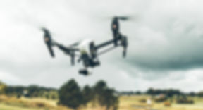
In the past, surveying, inspecting, and mapping assets were costly and inefficient processes. Workers faced dangers and wasted valuable time producing essential reports. However, with the advent of drones (UAVs), these complications can now be effectively addressed. UPLIFT offers a cost-effective and safe solution, leveraging drones to increase business efficiencies and propel you into the next generation of asset monitoring and mapping.
Industries

Surveys & Mapping

Property
.jpeg)
Inspections

Agriculture

Energy

Insurance
Construction Progress
CONSTRUCTION | PROPERTY | INFRASTRUCTURE
Harnessing our state-of-the-art drone technology and advanced software, UPLIFT has the capability to produce aerial time-lapses and reconstruct sites as dynamic 3D models over time. This creates an awe-inspiring visual display that captivates and impresses your clients.


Drone Inspections
SAFE | EFFICIENT | BUDGET FRIENDLY
Inspecting assets at dangerous heights or in hard-to-reach areas, such as machinery, roofing, and chimneys, poses significant challenges in terms of occupational health and safety (OH&S) and potential operational downtime. At UPLIFT, we address these complexities by utilizing drones equipped with high-resolution cameras. These drones can hover in close proximity to inaccessible areas, ensuring the safety of your workers who can remain on the ground. With rapid deployment and precise navigation, our drones can quickly reach the designated area of interest. Furthermore, our advanced technology enables us to provide your team with a live HD video feed, allowing operators or office personnel to have real-time visual access to the inspection process.
To enquire about our capabilities contact us
Mapping & Surveying
2D | 3D | VOLUME ESTIMATES
UAVs (Unmanned Aerial Vehicles) offer remarkable capabilities for creating high-resolution and precise imagery suitable for mapping and land surveying purposes.
At UPLIFT, we pride ourselves on our efficiency. Our team can swiftly mobilize and have the UAV in the air within minutes of arriving at the site. In just a matter of hours, we provide you with a user-friendly interface to access the captured data.
The aerial imagery we capture is geo-referenced and ortho-rectified with exceptional accuracy. This allows for direct measurements to be taken from the drone images, including area, distance, volume calculations, and elevation models.
Our systems are equipped with pre-programmed flight paths, making them ideal for time-lapse analysis. This functionality proves invaluable to industries such as construction, commercial real estate, and more, enabling you to gain valuable insights from the collected data.


Property Photos & Video
SHOWCASE | INTERIOR | EXTERIOR
Elevate your property marketing with our professional drone photography and video services. Our team at UPLIFT specializes in capturing stunning aerial shots that showcase properties from unique perspectives. With our state-of-the-art drones equipped with high-resolution cameras, we provide high-quality images and captivating videos that highlight the key features and beauty of each property. Whether you're selling residential or commercial property, our aerial imagery adds a dynamic and engaging element to your marketing materials. Stand out from the competition and leave a lasting impression on potential buyers with our property drone photography and video services.